
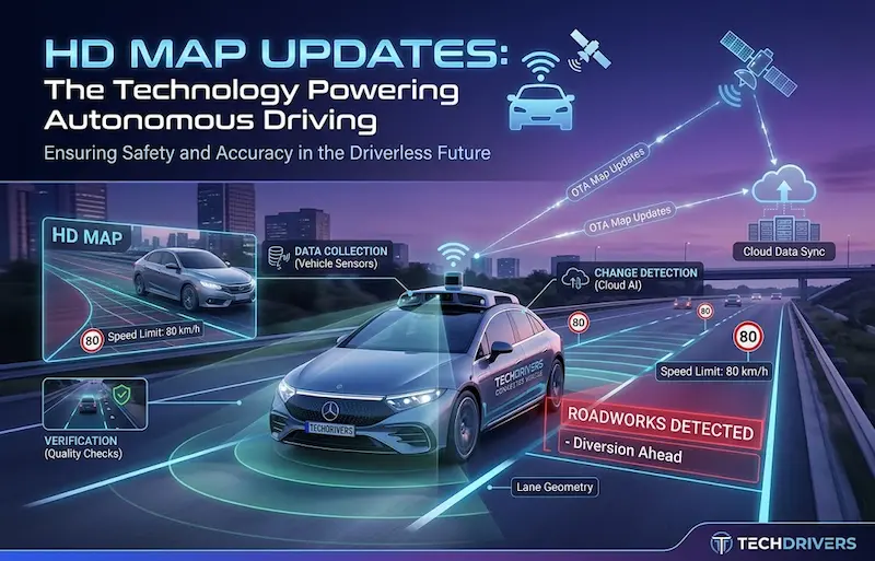

A self-driving car needs more than cameras and sensors to understand the road. It also needs reliable information about road layouts, lane positions, junctions, speed limits and changes to the driving environment.
That is where high-definition (HD) maps come in.
Unlike ordinary navigation maps, which mainly help drivers find routes, HD maps can provide detailed road information that supports vehicle positioning, advanced driver-assistance systems (ADAS) and some automated-driving functions. But roads are constantly changing. Construction works, new junctions, faded lane markings and temporary diversions can make previously collected map information outdated.
Over-the-air (OTA) HD map updates are designed to help vehicles receive revised map data wirelessly, without requiring every update to be installed manually at a workshop.
The technology is part of the wider shift towards connected vehicles, software-based vehicle features and increasingly automated transport. For Kenya, where road conditions can change quickly and electric mobility is developing, the subject raises important questions about infrastructure, data privacy, connectivity and the future of imported vehicles.
What is an HD map, and how does it work?
A conventional digital map helps a driver identify a road, choose a route and navigate towards a destination. An HD map can go further by describing road features in much greater detail.
Depending on the system, that information may include:
- Lane boundaries and road geometry.
- The location of junctions, ramps and road splits.
- Road edges, curves and other fixed features.
- Traffic signs and speed-limit information.
- Reference points that help a vehicle estimate its position.
- Selected road attributes used by supported driver-assistance functions.
The exact level of detail and the way maps are used vary by manufacturer and vehicle system.
HD maps are not a replacement for cameras, radar or lidar. Sensors help a vehicle detect what is happening around it now, including other vehicles, pedestrians and unexpected obstacles. Map data provides additional context about the road and its expected layout.
Combining these sources can help a supported driving system understand where it is and how the road ahead is arranged. However, a map can be wrong or incomplete, and automated-driving systems must be designed to handle discrepancies safely.
Why HD maps need frequent updates
A road map is a representation of the real world at a particular point in time. The physical environment may change after the map is created.
Consider a road that has been mapped with two lanes in each direction. A roadworks project may close one lane, change traffic flow or introduce a temporary diversion. A newly constructed roundabout could also alter how vehicles should approach an intersection.
If a vehicle relies on outdated information, the difference between the map and the real road can create problems for navigation or supported automated-driving functions.
Map providers therefore need ways to detect changes, verify them and distribute corrected information.
A research overview published in 2024 describes HD-map creation and maintenance as an ongoing process involving data collection, change detection, map updating and quality assessment. It also discusses the challenges of using data collected by vehicles with consumer-grade sensors.

arXiv
This is the problem that OTA map updates aim to address.
How over-the-air HD map updates work
1. Vehicles collect observations
Cameras and other sensors detect road features. Depending on the vehicle and service, relevant information may be processed onboard or sent to a mapping provider.
2. Potential changes are identified
Mapping software compares new observations with existing map data to identify possible changes, such as altered lane markings or a modified junction.
3. Changes are checked
Automated systems can help assess discrepancies, but the provider may need additional observations, validation rules or human review before accepting a change.
4. Updated map data is distributed
The provider sends relevant map changes to compatible vehicles through a supported wireless connection, often using cellular connectivity or Wi-Fi.
5. The vehicle verifies the update
The vehicle’s software must handle the update securely and confirm that the data is suitable for the relevant system before it is used.
The process can reduce dependence on repeated surveys by dedicated mapping vehicles. It does not eliminate the need for accurate surveys, quality checks or specialist mapping teams.
Nor does OTA mean every map changes instantly. The speed of an update depends on how quickly a change is detected, how it is verified, the provider’s update process, connectivity and the vehicle’s software capabilities.
What is driving the HD map update market?
Automakers are investing in connected services and driver-assistance technology. At the same time, mapping providers are exploring ways to maintain detailed road data across growing vehicle fleets.
The main drivers include the following.
1. Growth in driver-assistance systems
Modern vehicles increasingly offer functions such as lane-keeping assistance, adaptive cruise control and navigation-linked driving support.
These features do not all require HD maps, and some rely primarily on onboard sensors. However, high-quality map information can provide useful context for certain supported systems, particularly those that need precise road geometry or information about the route ahead.
As automakers expand these features across more models, the need to maintain relevant software and map data may increase.
2. Connected vehicles and wireless software delivery
Many newer vehicles can connect to mobile networks or Wi-Fi. That connection can support software updates, connected navigation and other remote services.
HD map updates are one possible use of this connectivity. Rather than replacing an entire map database each time, a system may distribute smaller changes for selected areas, depending on how the service is designed.
Cellular networks can support updates while a vehicle is in use or parked, while Wi-Fi may be useful for larger downloads at home or in a fleet depot.
Satellite connectivity may also be relevant in some systems, but availability, cost and technical capability vary.
3. Fleet operators want to reduce downtime
Commercial fleets need reliable information about routes, road restrictions and changing infrastructure. Connected navigation and fleet-management systems can help operators update route data across multiple vehicles.
For trucks, buses, taxis and delivery vehicles, wireless updates can reduce the need for manual interventions. The benefits will depend on the fleet’s existing systems, how updates are managed and whether its vehicles actually use HD maps.
4. Recurring digital services
Connected vehicle services create opportunities for subscription products and recurring software revenue.
Depending on the manufacturer and market, drivers may pay for navigation services, connected features or software packages. Mapping companies can also provide map data and maintenance services to vehicle manufacturers and other customers.
However, OTA map updates do not automatically mean that every driver will pay a separate subscription. Some services may be included with the vehicle, bundled into a wider package or provided under a commercial agreement.
How large is the HD map update market?
Market research firm Dataintelo lists the global HD Map Update Over-the-Air market at US$1.48 billion in 2024 and forecasts US$5.09 billion by 2033, while also stating a compound annual growth rate (CAGR) of 17.2%. The report identifies passenger and commercial vehicles, cellular connectivity, satellite and Wi-Fi among its market segments.
Dataintelo
These numbers should be treated as a commercial research firm’s estimates, not audited industry totals.
There is also a mathematical inconsistency in the headline forecast. Growing from US$1.48 billion in 2024 to US$5.09 billion in 2033 implies a CAGR of approximately 14.7% over nine years, rather than 17.2%. A CAGR of 17.2% over that same period would produce a higher 2033 value.
The report’s forecast period or underlying assumptions may help explain the discrepancy, but the public summary does not resolve it clearly. TechDrivers therefore does not present the market’s final value or CAGR as settled facts.
The broader direction is plausible: connected vehicles, driver-assistance features and ongoing map maintenance create demand for this type of service. The precise market size and speed of growth remain uncertain and can differ depending on how each research firm defines the market.
Which regions are leading?
Dataintelo’s report estimates that North America accounted for around 38% of the market in 2024, Europe about 30% and Asia-Pacific approximately 25%. These are the research firm’s estimates, rather than independently confirmed market shares.
Dataintelo
Asia-Pacific is important because of its large automotive industry, investment in connected vehicles and development of automated-driving systems. China, Japan and South Korea are among the markets to watch, although the regulatory environment and mapping-data requirements differ between countries.
For Africa, the near-term opportunity is likely to be more closely connected to digital mapping, fleet telematics, connected navigation and selected driver-assistance applications than widespread deployment of fully autonomous vehicles.
What does regulation mean for HD map updates?
HD map updates sit at the intersection of vehicle safety, cybersecurity, software maintenance and data protection. The regulatory question is not simply whether a map is accurate, but also whether the vehicle’s software can receive and use updates safely.
Vehicle cybersecurity and software updates
The United Nations Economic Commission for Europe (UNECE) has established vehicle regulations addressing cybersecurity management and software-update management, including UN Regulations No. 155 and 156. These frameworks are relevant to manufacturers operating in markets where the regulations have been adopted and apply to the vehicle types and approval processes within their scope.
For a manufacturer, the practical questions include how updates are authenticated, how software versions are tracked, how failures are handled and how the vehicle can recover from an unsuccessful update.
HD map data should not automatically be assumed to fall under one identical approval process in every country. Its treatment depends on how the map is integrated into the vehicle and the applicable requirements.
Global rules for automated driving
On 24 June 2026, UNECE announced that its World Forum for Harmonization of Vehicle Regulations had approved a global framework for fully automated driving systems. The framework focuses on safety validation, management of safety risks and monitoring after deployment. Its practical effect depends on the relevant approval and implementation arrangements.
UNECE
This is important for HD map providers because automated-driving systems need to be tested and monitored as they operate in real-world conditions. Where maps influence a vehicle’s driving decisions, manufacturers need a way to understand which map data was available and how the system responded when real-world observations differed from it.
Global frameworks do not automatically become identical domestic laws everywhere. Manufacturers and importers must still establish which rules apply in each market.
Privacy and Kenya’s Data Protection Act
Crowdsourced map maintenance may involve observations collected by vehicles moving through public spaces. Depending on the system, the data could include location information, images, vehicle identifiers or details that make people identifiable.
Kenya’s Data Protection Act, 2019, is relevant where personal data is processed within its scope. The Office of the Data Protection Commissioner identifies location data, identifiable images and other information relating to an identifiable person as personal data.
Data Protection Office
For vehicle and mapping businesses, responsible data handling should include:
- Collecting only the data needed for a defined purpose.
- Limiting the retention of raw camera footage and location records.
- Removing or obscuring identifiable information where appropriate.
- Applying access controls and protecting stored and transmitted data.
- Establishing a lawful basis for processing and providing required information to affected people.
- Assessing whether registration or other compliance obligations apply.
These considerations matter even before fully autonomous cars become common in Kenya. Connected vehicles, fleet telematics and location-based services already create questions about how mobility data is collected, stored and shared.
The technology: How maps stay current
Maintaining an HD map requires a pipeline that turns observations into dependable information. Several technologies help make that process more efficient.
Crowdsourced mapping
Instead of relying exclusively on dedicated mapping vehicles, providers can use observations from compatible vehicles already travelling on roads.
This approach can increase the frequency of observations, particularly in areas where many vehicles operate. But one vehicle’s observation may be incomplete, inaccurate or affected by poor visibility.
A reliable service therefore needs to assess confidence, compare observations and reject changes that cannot be validated sufficiently.
Edge computing and AI
Edge computing allows a vehicle to process some information locally rather than sending all raw sensor data to a remote server.
For example, software might identify a likely change in lane geometry and transmit a compact description of that change instead of uploading continuous video. This can reduce bandwidth requirements and limit the amount of raw data transferred.
Artificial intelligence can help compare observations against existing map information, detect inconsistencies and prioritise changes for review. However, AI-generated suggestions should not be treated as proof that a road feature has changed. Safety-sensitive updates need appropriate validation.
Cellular connectivity and Wi-Fi
Cellular connections can deliver updates to connected vehicles across wide areas, while Wi-Fi can be useful for larger downloads when a car is parked or connected to a home or depot network.
The ideal approach depends on update size, urgency, network availability and the vehicle’s design. A system may use different channels for different types of data.
For Kenyan fleet operators, this raises a practical issue: a vehicle may travel through areas where connectivity is inconsistent. A robust system needs to handle interrupted downloads, delayed updates and the possibility that a current map is temporarily unavailable.
Will AI make HD maps obsolete?
One debate in autonomous driving is whether increasingly capable AI systems will eventually drive using cameras and other sensors without depending on highly detailed pre-built maps.
The argument for mapless driving is that a system should respond to what its sensors observe, rather than relying heavily on a stored representation that might be outdated. Fewer dependencies on detailed maps could also reduce mapping costs and some data-maintenance challenges.
The opposing view is that maps provide useful information beyond what a vehicle can reliably observe at a particular moment. A map can describe road geometry ahead, support localisation and provide context for route planning. Cameras can also be affected by poor weather, glare, obstruction or faded markings.
The likely direction is not necessarily a choice between two completely separate approaches. Some systems may use detailed HD maps, others may rely more heavily on onboard perception, and some may combine sensors with lighter map layers.
The appropriate design depends on the vehicle’s intended capabilities, operating conditions, safety requirements and cost constraints.
The important distinction: an HD map is a supporting source of information, not a guarantee that a vehicle can drive autonomously or safely handle every road condition.
Industry examples: How mapping partnerships work
Several established technology companies illustrate the different approaches being used to maintain digital road information.

HERE Technologies and Mobileye
HERE’s HD Live Map and Mobileye’s Road Experience Management technology illustrate how data collected by equipped vehicles can help identify changes in road conditions and support map maintenance. The precise data-sharing arrangements depend on the service and partnership.

TomTom and DENSO
TomTom’s mapping technology and DENSO’s automotive systems illustrate the role of processed vehicle data in map services. TomTom has used the term Roadagrams for compact, crowdsourced information intended to help maintain road-map accuracy.

China’s automated-driving development
China is an important market to watch because of its automotive scale and investment in automated-driving technology. However, approval for a particular vehicle or operating area should not be interpreted as evidence that fully autonomous driving is ready for unrestricted use on every road.
These examples illustrate a broader industry trend: vehicle data, mapping services and software are becoming more closely connected. They do not establish that all manufacturers use the same mapping architecture or that a single provider dominates the entire market.
What HD map updates could mean for Kenya
Kenya is unlikely to adopt fully autonomous vehicles across the entire road network overnight. The more immediate relevance lies in connected navigation, fleet management, vehicle software and the gradual arrival of increasingly sophisticated driver-assistance systems.
Kenya’s road environment also presents challenges that map providers need to account for. Roadworks, diversions, mixed traffic, changing lane markings and differences in road quality can complicate the task of maintaining accurate map data.
Here are five areas worth watching.
1. Nairobi’s changing road network
Roadworks, new interchanges, altered junction layouts and temporary diversions can change the route a driver needs to follow.
A mapping service that detects and verifies changes quickly can help keep navigation information current. However, an updated map cannot replace temporary road signs, traffic officers or the driver’s obligation to respond to actual road conditions.
2. Public transport and commercial fleets
Buses, delivery vehicles, taxis and logistics fleets can benefit from connected navigation and centralised route management.
An operator managing vehicles across Nairobi, Mombasa, Kisumu or Nakuru may need to distribute route changes and manage vehicle software remotely. That does not always require a full HD map, but it illustrates how the wider connected-mobility ecosystem can create demand for better digital road data.
3. Electric vehicles and connected software
Electric vehicles are part of the broader shift towards software-enabled transport. Some models include connected navigation, remote diagnostics and wireless software updates.
The importance of HD maps will depend on the particular vehicle and its supported features. An electric vehicle is not automatically autonomous, and not every electric vehicle needs a high-definition map.
TechDrivers has also covered Kenya’s wider electric-mobility infrastructure. Read our report on Kenya’s removal of the EV charging tariff cap, which explains a separate but important part of the country’s transition towards connected and electric transport.
4. Electric motorcycles and battery-swapping networks
Electric motorcycles are an increasingly visible part of Kenya’s electric-mobility market. For these vehicles, the near-term digital priorities may be navigation, fleet tracking, battery monitoring and locating charging or battery-swapping facilities rather than autonomous driving.
Our article, 10+ Electric Motorcycle Brands Set to Enter Kenya as Battery-Swapping Network Opens the Market, examines the infrastructure and competition shaping this sector.
As connected mobility expands, mapping and location services could become more useful to riders, fleet managers and infrastructure providers. But HD maps would need to demonstrate a practical benefit before becoming a major standalone investment for these businesses.
5. Data protection and public trust
Connected vehicles can generate location and sensor data that reveal patterns about where people travel and when they travel.
Businesses operating in Kenya should consider how this information is collected, whether it can identify individuals, who can access it and how long it is retained.
Trust will matter alongside technical performance. A useful mapping service must not only provide accurate information but also manage the data behind that service responsibly.
Risks and limitations businesses should understand
Despite the potential benefits, OTA HD map updates come with significant challenges.
| Risk | Why it matters |
|---|---|
| Outdated or incorrect data | A map can differ from the actual road, so vehicles must not treat it as infallible. |
| Cybersecurity | Malicious or unauthorised updates could undermine the integrity of vehicle data. |
| Connectivity gaps | Vehicles may not receive updates immediately in areas with weak or unavailable networks. |
| Cost | Mapping, verification, storage and distribution require ongoing investment. |
| Privacy | Vehicle observations may contain personal or sensitive location information. |
| Compatibility | Different manufacturers may use different data formats, update systems and technical requirements. |
| Uncertain demand | Mapless or sensor-led driving systems could reduce the need for some types of detailed map data. |
For Kenya, the cost question is particularly important. Before investing in an HD mapping solution, a fleet operator should identify the operational problem it needs to solve and compare the expected benefits with the cost of software, connectivity, hardware and maintenance.
What should decision-makers watch next?
Four developments will help determine the future of OTA HD map updates.
- The reliability of crowdsourced data: Can providers detect road changes accurately and quickly without excessive collection of raw footage?
- The balance between maps and onboard AI: Will vehicles continue to need detailed HD maps, or will lighter map layers become sufficient for more applications?
- Vehicle cybersecurity and safety requirements: How will regulations and approval processes develop as more automated-driving features reach commercial markets?
- The business model: Will map maintenance be bundled with vehicles, sold through subscriptions or supplied through agreements between mapping providers and automakers?
For Kenyan businesses, a fifth consideration is whether the technology can be adapted to local road conditions and connectivity realities at a commercially sensible cost.
Frequently asked questions
What is an HD map in autonomous driving?
An HD map is a highly detailed digital representation of road features such as lane geometry, road edges and junction layouts. Depending on the vehicle system, it can support localisation, navigation and selected automated-driving or driver-assistance functions.
What does OTA mean in vehicle technology?
OTA stands for over the air. It refers to delivering software or data wirelessly rather than requiring a physical connection or manual installation. Vehicles may receive supported map and software updates over cellular networks or Wi-Fi.
Do all autonomous vehicles need HD maps?
No. Different vehicle systems use different combinations of cameras, radar, lidar, onboard computing and map data. Some rely heavily on detailed maps, while others place greater emphasis on sensor-based perception. The requirements depend on the system’s design and intended operating conditions.
Can an HD map update make a vehicle safer?
A verified update can help a compatible system work with more current road information. However, safety depends on the quality of the map, the vehicle’s sensors and software, validation processes and how the system responds when information is incomplete or incorrect. An update alone cannot guarantee safer driving.
Is HD map update technology widely used in Kenya?
There is no basis here to claim that OTA HD maps are widely deployed across Kenyan vehicles. Connected navigation, fleet tracking and driver-assistance features are more immediate areas to examine. The scale of local HD map deployment will depend on vehicle availability, infrastructure, connectivity and commercial demand.
How does Kenya’s Data Protection Act relate to connected cars?
Where connected-vehicle services process personal data within the Act’s scope, businesses need to consider lawful processing, transparency, security, data minimisation and applicable data-subject rights. Location information and identifiable images can qualify as personal data. The precise obligations depend on the processing activity and circumstances.
Is the HD map update market really worth US$5.09 billion by 2033?
That is a forecast published by Dataintelo, not a confirmed future market value. Its public summary also states a 17.2% CAGR, which does not mathematically align with the stated 2024 and 2033 values over nine years. Readers should treat the forecast cautiously until the discrepancy is clarified.
Dataintelo
Will mapless AI replace HD maps?
It remains uncertain. Sensor-led systems may reduce dependence on highly detailed maps in some applications, while other systems may continue using maps for road context, localisation and planning. A combination of sensors and updated map data is also possible.
Conclusion
By helping compatible vehicles receive verified map data wirelessly, OTA services can support more current navigation information and selected driver-assistance or automated-driving functions. The technology also creates opportunities for mapping providers, automakers and fleet-management businesses.
But market forecasts should be treated carefully, map accuracy is not guaranteed, and cybersecurity, privacy and validation remain essential. The debate over detailed maps versus increasingly capable AI-driven perception is also unresolved.
For Kenya, the immediate opportunity is not to assume that driverless cars will suddenly become common. It is to follow how connected navigation, fleet telematics, electric mobility and vehicle software develop, while ensuring that data protection and local road conditions are considered.
The future of autonomous driving will depend not only on how well a vehicle sees the road, but also on how reliably it understands the road, updates that understanding and responds when reality differs from the map.
