
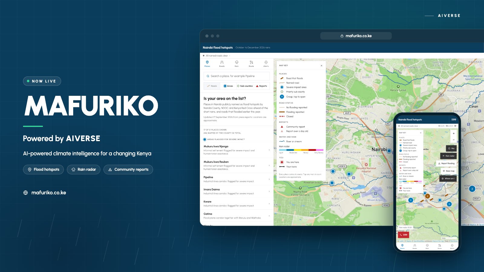

Kenya is increasingly turning to technology and data to improve how communities prepare for climate-related disasters. One of the latest examples is Mafuriko, a community-powered flood warning platform designed to bring together information about flooding and conditions on the ground.
According to its launch announcement, Mafuriko combines flood hotspots, rainfall data, affected roads and community reports to provide a real-time picture of flooding. The platform also allows members of the public to report flooding, creating a two-way system in which communities can contribute information rather than simply receive warnings.
The platform was built by Esoteric Strats and powered by AIVERSE Africa, according to the announcement shared by the organisations behind the project.
What Is Mafuriko?
Mafuriko is a digital platform focused on flood monitoring and early warning.
Its central idea is relatively straightforward: combine different sources of information about flooding in one place and allow people experiencing floods to contribute reports.
The platform brings together information such as:
- Flood-prone or reported flood hotspots
- Rainfall information
- Roads affected by flooding
- Community reports
- Information about conditions on the ground
This type of system can be useful because flooding can change quickly.
A road that was passable in the morning can become difficult or impossible to use later in the day. Community reports can therefore add another layer of information alongside weather and rainfall data.
How the Mafuriko Flood Warning System Works
The Mafuriko model is based on combining data with reports from people in affected areas.
1. Flood and rainfall data
Weather and rainfall information can help provide context about conditions that may contribute to flooding.
Rainfall data alone, however, does not necessarily show what is happening on every road or in every neighbourhood.
2. Flood hotspots
Mapping flood hotspots can help users identify locations where flooding has been reported or where flood risk is relevant.
For people planning journeys, this information could provide additional context when deciding whether a particular route may be affected.
3. Affected roads
Road conditions are particularly important during flooding.
A flood warning becomes more useful when people can understand not only that heavy rainfall is occurring, but also whether specific roads or routes are affected.
For commuters, public transport users, delivery businesses and emergency responders, this type of information can have practical value.
4. Community reporting
One of the most important parts of Mafuriko is its community-reporting component.
Members of the public can report flooding, helping add information from locations that may not be adequately covered by conventional monitoring infrastructure.
That creates a feedback loop:
Weather and rainfall data → flood information → community reports → updated picture of conditions
The quality of such a system will ultimately depend on the accuracy, timeliness and coverage of the information being submitted.
Why Flood Technology Matters in Kenya
Flooding is not simply a weather story. It can become a technology and infrastructure problem.
When roads are flooded, people can lose access to transport routes, businesses can experience disruption and emergency services can face difficulties reaching affected communities.
Kenya has already recognized the importance of digital technology in disaster preparedness.
In 2025, the Communications Authority of Kenya reported that the government was placing ICT at the centre of its Early Warnings for All initiative. The framework includes data collection and risk assessment, observation and forecasting, dissemination and communication, and community response.
The government has also been working on measures including emergency communications, disaster connectivity mapping and a cell-broadcast emergency alerting system.
Mafuriko fits into this broader shift toward using digital infrastructure and data to make disaster information more localized and actionable.
How Mafuriko Could Help Kenyan Communities
The usefulness of a flood platform depends on how quickly people can turn information into action.
For an ordinary Kenyan user, the potential applications are practical.
Commuters
Someone travelling through Nairobi or another flood-prone area could use flood information to understand whether roads on their route have been affected.
Businesses
Businesses that depend on deliveries, logistics or regular movement of staff could use information about affected roads when planning operations.
Communities
Residents can contribute local information by reporting flooding rather than waiting for information to reach them through traditional channels.
Emergency response
Accurate and timely reports can potentially provide responders with additional situational information, although Mafuriko should not be treated as a replacement for official emergency services.
A Nairobi Example
Consider a period of heavy rainfall in Nairobi.
Rainfall data may show that substantial precipitation is occurring. But a resident travelling from one part of the city to another may have a more immediate question:
Which roads are actually affected right now?
A community-powered system can potentially add this local layer.
For example, if several users report flooding on a particular road, that information can help create a more detailed picture of the situation than rainfall data alone.
The same principle could apply to other flood-prone areas across Kenya.
The important distinction is that weather information tells users about conditions in the atmosphere, while community reporting can provide information about what people are experiencing on the ground.
Mafuriko and Kenya’s Growing Use of Technology for Public Problems
Mafuriko is part of a broader pattern in Kenya: technology companies and local developers increasingly building digital products around problems that affect everyday life.
This includes fintech, mobility, telecommunications, AI and digital public services.
TechDrivers has previously examined how Kenya’s technology ecosystem is expanding beyond consumer apps and into infrastructure and enterprise technology.
Our article on Nairobi’s rise as East Africa’s technology hub looked at how mobile connectivity, entrepreneurship, investment and digital adoption have contributed to the city’s technology ecosystem.
Mafuriko provides another example of technology being applied to a distinctly local problem.
The AI Connection
Mafuriko is also relevant to the wider conversation about artificial intelligence and data systems in Kenya.
However, it is important to distinguish between a platform using data and a platform whose specific AI capabilities have been independently documented.
The announcement describes Mafuriko as a community-powered early warning system and says it brings together different sources of flood information. That is the basis for describing its data-driven approach.
Kenya’s wider technology ecosystem is simultaneously seeing more investment in AI infrastructure and skills.
For example, TechDrivers recently reported on Meta and This Is Digital’s AI Academy Kenya, which focuses on developing practical AI skills among Kenyan developers, students, startups, professionals and businesses.
The connection is important because building useful local technology does not always mean creating another general-purpose chatbot. It can mean applying software, data, AI and digital infrastructure to specific problems.
What Could Make Mafuriko More Useful?
For a flood-warning platform to become genuinely useful at scale, several factors matter.
Reliable data
The system needs accurate and timely information.
Strong community participation
A community-powered platform becomes more valuable when people consistently submit useful reports from affected locations.
Clear verification
Flood reports need mechanisms for identifying outdated, inaccurate or duplicate information.
Wide geographic coverage
Flooding affects different parts of Kenya differently. A platform focused on only one urban area would have limited national usefulness.
Reliable connectivity
People need to be able to access the platform during the very situations when it is most needed.
This is particularly important because disasters can disrupt infrastructure.
Integration with official warnings
Community-generated information can complement official systems, but users should still pay attention to government emergency alerts and instructions.
Why Community Reporting Matters
Traditional disaster monitoring systems often depend on formal infrastructure such as weather stations, sensors and government reporting networks.
Community reporting adds another layer.
A person standing on a flooded road can potentially provide information about a situation that may not yet be reflected in a centralized dataset.
That does not make every community report accurate.
Instead, it highlights the importance of combining multiple sources.
The strongest systems can potentially compare rainfall information, geographic data, road conditions and reports from people on the ground.
What Mafuriko Means for Kenyan Technology
Mafuriko illustrates an important direction for Kenya’s technology ecosystem.
Some of the most useful digital products may not be designed simply to entertain users or make existing tasks slightly faster.
They may be built around problems involving mobility, weather, infrastructure, public safety and access to information.
This is also consistent with the wider direction of Kenya’s digital ecosystem, where technology is increasingly being connected to physical infrastructure.
TechDrivers has previously covered developments ranging from AI operations platforms to Kenya’s growing data-centre infrastructure.
Our report on Airtel’s planned $150 million data centre in Kenya examined how infrastructure investment is supporting demand for cloud computing, AI and digital services.
Mafuriko represents a different layer of the technology stack: using digital information to help people understand conditions in the physical world.
Frequently Asked Questions
What is Mafuriko?
Mafuriko is a community-powered flood warning platform designed to bring together flood hotspots, rainfall data, affected roads and community reports.
Who built Mafuriko?
The launch announcement says Mafuriko was built by Esoteric Strats and powered by AIVERSE Africa. Esostrats describes itself as an African technology group working across software engineering, AI, cloud infrastructure, data systems and related technology services.
Can people report flooding on Mafuriko?
Yes. According to the platform’s launch announcement, members of the public can report flooding to help build a real-time picture of conditions on the ground.
Is Mafuriko an official government emergency system?
The information available for this article describes Mafuriko as a community-powered flood warning platform. It should not be assumed to replace official government emergency warnings or response services.
Why are flood reporting platforms important in Kenya?
They can potentially provide more localized information by combining data with reports from people experiencing flooding directly. This complements Kenya’s broader push toward ICT-enabled early warning and disaster preparedness.
Can Mafuriko predict floods?
The available launch information establishes that the platform brings together rainfall, flood hotspots, affected roads and community reports. It does not provide enough information to independently claim that Mafuriko can predict every flood event. Users should therefore distinguish between flood monitoring, reporting and formal forecasting.
The Bigger Picture
Kenya’s approach to disaster preparedness is increasingly becoming digital.
Government agencies are expanding ICT-enabled early-warning capabilities, while technology companies and developers are building platforms that can bring information closer to communities.
Mafuriko sits within that changing landscape.
Its most interesting feature may not simply be the map or the technology behind it, but the idea of combining data from digital systems with information from people experiencing events in real time.
For a country where heavy rainfall can quickly affect roads, businesses and communities, making localized information easier to access could be an important part of improving preparedness.
Conclusion
By bringing together rainfall data, flood hotspots, affected roads and community reports, the platform aims to give users a more localized picture of flooding.
Its long-term usefulness will depend on factors such as data quality, community participation, geographic coverage, verification and integration with official emergency systems.
But the underlying idea is significant: technology does not always have to solve a global problem to be valuable.
Sometimes the most useful technology is built around a problem that people in a particular community experience every rainy season.
